7 Bridges Walk
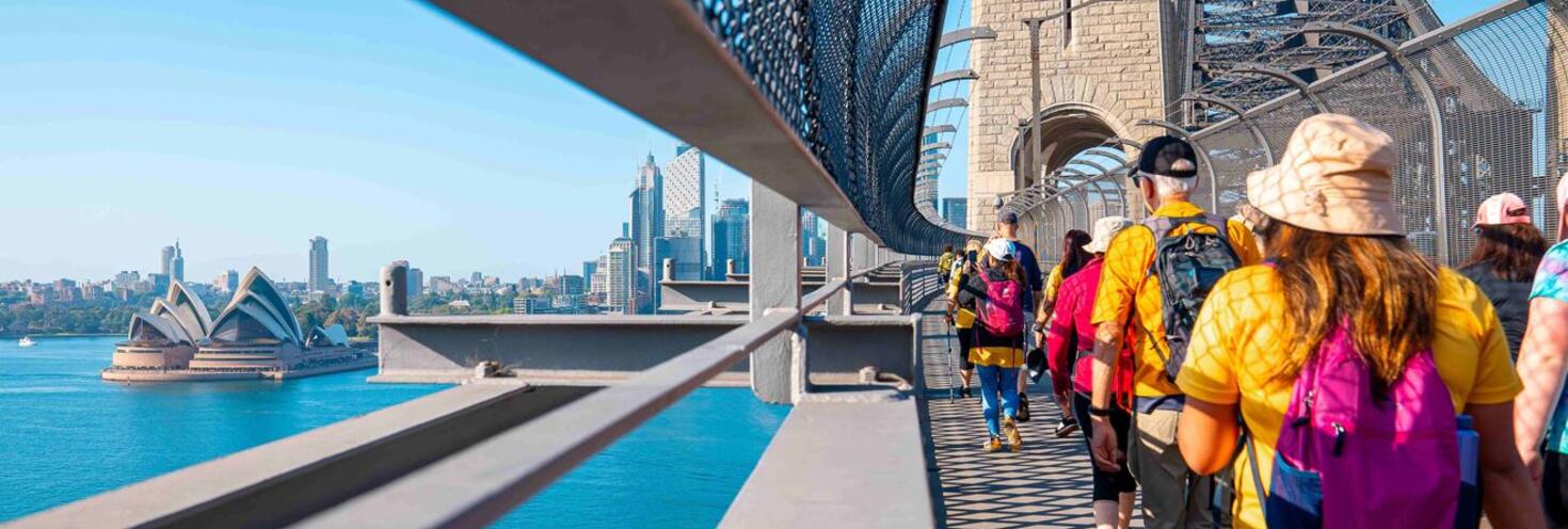
Sydney Harbour Bridge, Anzac Bridge, Pyrmont Bridge, Iron Cove Bridge, Fig Tree Bridge, Gladesville Bridge & Tarban Creek Bridge
-
Start
07:30
Finish 16:30
Important Event Information
Thousands of participants are expected to take part in this year’s 7 Bridges Walk crossing seven bridges along a 28km walk raising funds for Cancer Council NSW. Participants will walk in a clockwise direction on footpaths and dedicated shared paths with some lane closures in place along the course.
Travel on public transport is included with participation and volunteer event registrations. Free shuttle buses will also run in a loop of the course between 8:30am and 4:30pm. See the 7 Bridges Walk Course Map for Event Village and bus stop locations.
Participants will cross the following seven bridges:
- Sydney Harbour Bridge
- Pyrmont Bridge
- Anzac Bridge
- Iron Cove Bridge
- Gladesville Bridge
- Tarban Creek Bridge
- Fig Tree Bridge
Participants can start the course at any of the six event villages including:
- Milsons Point Village - Bradfield Park, corner of Fitzroy St & Alfred St South in Milsons Point
- Pyrmont Village - Pyrmont Bay Park, Pirrama Rd, opposite The Star
- Rozelle Village – Callan Park, Corner of Waterfront Drive and Military Drive, Lilyfield
- Hunters Hill Village – Hunters Hill Scouts Hall, Durham St, near the Church St overpass on Burns Bay Rd
- Lane Cove Village - Blaxlands Corner, corner of William Edward St and Kenneth St
- Wollstonecraft Village - Brennan Park, Hazelbank St and King St
The latest start time recommended to complete the full circuit is 11am. Participants are issued with an event guide to be stamped at each bridge and village, and a course map.
For changed traffic conditions visit livetraffic.com.
Ticket entitlements
7 Bridges Walk 2024 participants and volunteers are entitled to travel to and from the event on Sunday 20 October 2024 on the following public transport services – just show your participant travel pass to transport staff when boarding services.
- Sydney Trains and NSW TrainLink Intercity services (non-booked services bounded by Bomaderry, Goulburn, Bathurst, Scone and Dungog stations)
- Note: an additional train station access fee (GatePass) applies for travel to or from Domestic and International Airport stations. The access fee is not covered by your event ticket travel entitlements.
- Sydney metropolitan buses and NightRide
- Sydney Metro services.
- Sydney Ferries
- Sydney Light Rail
Remember to keep your event transport pass safe for your return journey or you'll need to use your Opal card or contactless payment method, as you must have a valid ticket when travelling on public transport. Your event ticket is valid on the modes of public transport listed above until 4am the following day.
Note: an additional train station access fee applies for travel to or from Domestic and International Airport stations. The access fee is not covered by your event ticket travel entitlements.
Transport Park&Ride Car Parks
Transport Park&Ride provides up to 18 hours of free parking each day. 7 Bridges Walk participant travel passes include travel on transport and free Park&Ride parking, use the intercom button at the exit gate to speak with the operator. If you use a Transport Connect account to access Park&Ride, the boom gate will automatically open as you leave the car park so you’ll need to request a refund in your account. For Park&Ride locations and more information on how it works, go to Transport Park&Ride.
Sydney Metro services are high-frequency, driverless trains running between Sydney’s north-west and south-west via the city.
The M1 Line operates turn up-and-go Metro services in both directions between Tallawong, Chatswood and Sydenham.
Please note that due to planned weekend trackwork, metro services are not running between Tallawong and Sydenham. You will need to catch a replacement bus to Crows Nest station or a train instead. Plan your trip using the Trip Planner.
- M1 Metro Line: Metro services will not run between Tallawong and Sydenham. Buses replace services between Tallawong and Chatswood only. Use train services between Chatswood, the City and Sydenham.
For Metro service disruption information, check trackwork and travel alerts or plan your trip using the Trip Planner.
Milsons Point and Wollstonecraft villages are easily accessible from stations on the T1 North Shore Line. The remaining villages are best accessed by bus.
- Milsons Point Village, Bradfield Park corner of Fitzroy St & Alfred St South, is a short walk from Milsons Point Station.
- Wollstonecraft Village, at Brennan Park on Hazelbank Street and King Street, is a short walk from Waverton Station.
Trackwork
Planned weekend trackwork is taking place on Sunday 20 October on the following lines and may affect how you travel to and from the event. Plan ahead using the Trip Planner:
- M1 Metro Line: Metro services will not run between Tallawong and Sydenham. Buses replace services between Tallawong and Chatswood only. Use train services between Chatswood, the City and Sydenham.
- Hunter Line: From 10pm to 1.30am, buses replace trains between Newcastle Interchange and Telarah.
Trackwork is carried out on an ongoing basis to maintain the safety, reliability, and efficiency of the Sydney Trains network. For train service disruption information, check trackwork and travel alerts or plan your trip using the Trip Planner.
Free event shuttle buses
Free event shuttle buses will run around the course in both directions to help participants connect between Event Villages. Just show your Event Ticket or Event Guide when boarding services.
Please note: while dogs are welcome on the course, they are not permitted onboard buses (assistance animals excepted).
Shuttle buses will start running from Milsons Point at 8:30am, making their way around the course in both clockwise and anti-clockwise directions. The last service will leave Milsons Point at 4:30pm.
Buses will be available from the anti-clockwise bus stops every 30 minutes all day and for clockwise bus stops every 30 minutes in the morning and every 10 minutes in the afternoon.
Bus stop locations
- Milsons Point: Alfred St South outside Milsons Point station
- Wollstonecraft: King St opposite Brennan Park
- Greenwich: River Rd opposite Greenwich Hospital
- Blaxlands Corner: River Rd, near William Edward St
- Linley Point: Burns Bay Rd opposite View St
- Hunters Hill: Burns Bay Rd near the Church St on/off-ramp
- Drummoyne: Victoria Rd near Lyons Rd opposite the Drummoyne Post Office
- Rozelle: Victoria Rd near Callan St / Terry St
- Pyrmont: Pirrama Rd, outside The Star before Jones Bay Rd
Please note that some clockwise and anticlockwise bus stops are not located directly opposite each other. Clockwise bus service signage will include a ‘C’ after the bus stop number; anticlockwise services will include an ‘A’.
See the 7 Bridges Walk 2024 Course Map for village locations and bus stops.
Regular route buses
The Rozelle, Hunters Hill and Lane Cove Villages are best accessible by bus. Use the Trip Planner to find a bus service to get you to your chosen starting point.
For bus service disruption information check travel alerts or use the Trip Planner.
Sydney Ferries are a great way to get around the city, but services are very popular and may reach capacity, especially on weekends. Plan your trip ahead and allow plenty of extra travel time or consider the alternative transport options available.
Milsons Point and Pyrmont villages are easily accessible by ferry with wharves in short walking distance of the village sites. Remaining villages are best accessed by train or bus.
For service disruption information check travel alerts or use the Trip Planner.
L1 Dulwich Hill Line
L1 Dulwich Hill Line light rail services run between Central Station (Grand Concourse) and Dulwich Hill via Darling Harbour and the Inner West. Services run regularly from 5am to 1am daily. Plan your trip using the Trip Planner.
L2 Randwick and L3 Kingsford Lines
L2 Randwick Line light rail services run between Circular Quay and Randwick via Central Station (Chalmers Street) and L3 Kingsford Line services run between Circular Quay and Juniors Kingsford via Central Station (Chalmers Street). Services run regularly from 5am to 1am daily. Plan your trip using Trip Planner.
For maps and service frequencies see light rail service information. For light rail service disruption information, check travel alerts or plan your trip using the Trip Planner.
Participants will use existing off-road walkways and footpaths however there will be some minor road and lane closures in place to support pedestrian movements.
Pedestrians should take extra care, especially when crossing major roads. Drivers should also exercise caution and keep an eye out for walkers as there will larger groups of pedestrians walking along footpaths on key roads.
Road Closures
Lilyfield:
From 5am to 4pm the following roads within Callan Park will be closed:
- Central Ave between Military Dr and North Crescent/Waterfront Dr
- Military Dr between Wharf Rd and Central Ave
- North Crescent from Park Dr
- Waterfront Dr between Military Dr and Central Avenue
Hunters Hill:
- From 6am to 6pm Durham St at Church Street.
Lane Cove:
- From 7:30am to 4pm lane 1 eastbound of River Rd will be closed between Lane Cove Country Club driveway (Stevenson Street) and Greenwich Hospital Pedestrian Crossing (St Vincents Road).
For the latest traffic information visit Live Traffic NSW or download a real-time traffic app.
Local parking
Standard parking conditions apply in areas around each respective Village so check signs carefully.
Public transport is the best way to get to and from the event so consider driving to a nearby station to continue your trip on transport.
Transport Park&Ride Car Parks
Transport Park&Ride provides up to 18 hours of free parking each day. 7 Bridges Walk participant travel passes include travel on transport and free Park&Ride parking, use the intercom button at the exit gate to speak with the operator. If you use a Transport Connect account to access Park&Ride, the boom gate will automatically open as you leave the car park so you’ll need to request a refund in your account. For Park&Ride locations and more information on how it works, go to Transport Park&Ride.
Event
For information on the 7 Bridges Course accessibility including decision points, toilets, charging stations and contact information visit the event website.
Transport
Accessible trips are shown in the Trip Planner with the wheelchair icon. You can select "accessible services only" in the Options to ensure you only see accessible services. Only trip plans with accessible train platforms, ferry wharves and buses will be presented. See accessible travel or download a transport app (select the "Accessibility" filter).